A motorcycle trip to the birthplace of Buddha

A motorcycle trip to the birthplace of Buddha

After spending a couple of days relaxing in the backpackers luxury of Pokhara, I started becoming antsy again. I felt like going on one more little adventure before starting off on the Great Himalaya Trail. Based on the information of my travelguide I found out that Lumbini, the birthplace of Buddha, is about 220 kilometres away from Pokhara. The Prithvi Highway that takes you there is supposedly one of the nicest roads in Nepal to ride.

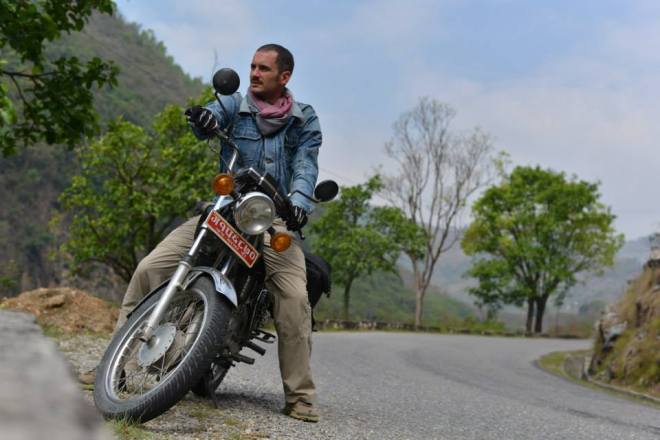
Not daunted by having a complete lack of motorcycle experience I walked into the office of Hearts & Tears. I signed up for a one day introduction class hoping this would give me enough driving skills to take on the trip the following days. In true Nepali fashion I got taught how to start, switch gears and brake in the middle of a public park surrounded by a troupe of local kids. After a morning of trial, error and increasing success, my teacher felt it was time to take me out on the road. After a short stretch through the slightly hectic traffic we made it out on a mountain road to work on my corner work. When we get back in the office I get the approval of my instructor signs to rent a bike for the next three days.
1511457_10154052597635173_7180898146177062314_n
The following morning I wake up early to beat the morning traffic and slowly make my way towards Lumbini. The Prithvi Highway turns out to a succession of beautifully carved turns, but I slowly make my way up and enjoy the freedom of riding on a motorcycle. Even if it’s just a measly Yamaha RX-135, it doesn’t stop me from dreaming of a longer Royal Enfield Bullet trip somewhere in the future.

After a long day I arrive into the small town of Lumbini Bazaar, on the edge of the Buddhist pilgrimage site. I check in to a hotel and walk in to the park just after sunset. The Maya Devi temple, the actual birthplace of Buddha, is already closed but I can convince the guards to let me sneak in to take some pictures. After quickly looking at the foundations of the original temple, I walk outside to find a group of pilgrims congregated around the pond chanting.
1425691_10154052599075173_7280842706118411987_n
Back at the hotel I begin to realize how different the climate is on the Terai. At only 150 metres above sea-level the temperatures don’t drop down at night. Combined with a killer force of mosquitoes I barely get some sleep at night. Long before sunrise I pack up my bags and get on my motorbike to explore the rest of this Unesco heritage site. I get to see a brightly orange sun rise over the World Peace Pagoda, where I’m joined by two Japanese monks who are hitting melodic cymbals while circumnavigating the pagoda.

Sunrise at the World Peace Pagoda

Sunrise at the World Peace Pagoda


From there on I ride along the various temples and pagodas that have been built here by the different countries. Some of them are small and humble, others huge and covered in gold. It’s an interesting experience to see how each temple has a different style (and also budget).
Young Nepali apprentices cleaning up their temple in the morning.

Young Nepali apprentices cleaning up their temple in the morning.


In the afternoon I drive up to the ruins of the palace in Tilaurakot where the young Buddha grew up and eventually left behind his royal life of comfort. Although not as impressive, the solitude here away from the typical tourist trail, sheds a different life on the experience. As I drive back towards Tansen where I’ll spend the night, I feel myself cutting through the thick warm air of the Terai. With a big smile on my face I can only conclude that my first motorcycle trip has turned out to be a great success.

As always you can find more pictures here.

From tomorrow on I’ll be together with Remy doing our final preparations for the Great Himalaya Trail. From here on I’ll have little internet access, but I hope to put up some posts after we have successfully finished that adventure.

David

My mere presence must not have pleased the goddess …

At least that’s what I think on the fourth day of my mountain biking adventure in remote Eastern Nepal. Only 24 hours before I had climbed up to the temple of Pathibara Devi. At 3794 metres high it isn’t just an amazing viewpoint of Kachenjunga and Makalu (three of the five highest peaks in the world), it’s also an important Hindu pilgrimage were thousands of devotees congregate to make offerings to the goddess in return for some godly intervention. I decided to ask the her to make my upcoming bike trip a safe one without any major inconveniences. I hadn’t taken up a goat with me for slaughtering, but left a 10 rupees note hoping that it would be sufficient for a first-time requester like me.

Pathibara Devi

Pathibara Devi


But now I was regretting not leaving a more valuable offering behind. Over the last 24 hours I had crushed twice on a downhill section, my chain who at the beginning of my ride sounded like a purring kitten had started to rattle like the last grasping of a dying chain-smoker, the chain would regularly jam on the steep up-hill, a while back I had lost my map of the region and now all of the sudden it started raining. Big, lush, tropical rain drops were slowly transforming the orange dusty dirt road I was riding on into a brightly red quicksand that heavily stuck to my tires. As I stopped along the road, I suddenly realised that it came to an end not even 50 metres further. So here I was in the middle of nowhere, miles away from a hotel or shop, slowly getting wet at the end of a road I was supposed to follow into the next village. On the edge of despair I sit down and watch small Nepali man walk towards me with a little smile on his face. He only speaks basic English and that’s a lot better than my basic Nepali, but he understands my predicament and invites me over to stay at his family’s house for the night. It would be a recurring team for this trip: me pushing on along a remote track and the warm Nepali hospitality and generosity saving my ass. Or as Paul Theroux says it so much better: “Most travel, and certainly the rewarding kind, involves depending on the kindness of strangers, putting yourself into the hands of people you don’t know and trusting them with your life.”
Fixing my chain problem at my kind guest's house.

Fixing my chain problem at my kind guest’s house.


How exactly did I get here you might ask. After returning from my Langtang hike I received some bad news. Two leaders of the JVF NGO I was supposed to work with had been involved in a horrific bus crash and as a consequence my project was postponed indefinitely. Off course I regretted this fact a lot, but I could easily understand that this small community had bigger worries right now than accommodating a volunteer. I hope that I might come back in the future to this great project.
One of many footbridges to cross along the way.

One of many footbridges to cross along the way.


The following day I woke up with the plan to rent a bike, jump on a bus and get as far East as possible before returning back by bicycle connecting small villages, dusty roads and hundreds of friendly people along the way. At times it definitely was rough and challenging, but most of the time it turned out to be an amazing experience. It’s hard to capture everything but these are just some of the great encounters I have experienced along the way:
– When I bicycle into Thembe and ask around for a place to have lunch, a teenager tells me he works in a hotel and shows me the way. Instead he takes me to a wedding and promptly I get turned into the guest of honour.
– Some of the stretches are too step to ride up, so I have to carry my bike on my shoulders for hours at times. During an afternoon like this I stumble upon a group of boys who show me the way to their swimming hole where I have an amazingly refreshing swim.
– Everywhere I pass local kids would scream “bicycle” at the top of their lungs and then run along with me for miles. But nowhere it was so overwhelming as riding along the school of Chepte in the middle of their break. All of the sudden I’ve got hundreds of students running along with me. I’ve got the biggest smile ever on my face and don’t even realise I’m missing a turn-off where I’ll have to return back to two hours later.
– One night I’m riding/climbing up a road that’s still under construction. At 17.30 the sun has already disappeared behind the ridge and I haven’t seen a house for the last hour. Starting to wonder where I’ll sleep/eat that night, I stumble upon a road construction crew. Once they hear my sad story they invite me to stay at their basic camp and share their food with me.
– When two mornings later I bike through a small town, I see several kids with bloody red hands and an old lady with a broom chasing them away. I can only figure out what it means once I stop in the next village and I get assaulted by kids with red powder, it’s Holi. The festival of colour and I’m gladly invited to participate.
Holi Festival

Holi Festival


In the end I’ve ended up bicycling 18 days in some of the remotest sections of Nepal. Starting from Ilam I went to Phiddim, Taplejung, Dobhan, Deurali, Chainpur, Bhojpur, Diktel, Okhaldunga, Rampur, Khiji to Dhare. I’ve run into only three other foreigners during this trip. But the hundreds of friendly Nepali people along the way make sure I never feel lonely along the way.
Along the way

Along the way


So what’s ahead for me now? Well, I’m currenlty in Pokhara to relax and try to put on some extra weight. In a week my friend Remy arrives here. We hiked together for a stretch on the PCT last year and we’ve decided to hike the Great Himalaya Trail together. What has been a dream I’ve hoped to realise in a couple of years from now all of the sudden has become a very big reality right now. It will probably be the most challenging undertaking I have ever done. Around 1500 kilometres of hiking along the crest of the might Himalaya range, crossing Nepal from East to West. I look forward to it as much as I’m afraid of it. It will be the pinnacle of all my hiking adventures till now.
Great Himalaya Trail

Great Himalaya Trail


You can find more pictures of my MTB trip here.

I’m back in the Himalayas …

and it’s an exhilarating feeling. Last year I spent five months volunteering with Quetzaltrekkers, an amazing organization in Guatemala. It turned out to be an incredibly rewarding experience for me and a big motivator to spend some more time doing good work around the globe. That’s why I’m currently in Nepal, one of my favourite countries in the world. I’ll soon start working for a local NGO: Jhumlawang Village Foundation. But before embarking on that mission, I wanted to get some hiking done.
1489212_10153902559805173_1031938918_n
After some research I decided to combine four different trails into one big loop: Tamang Heritage Trail – Langtang Valley – Gosainkunda – Helambu. I left Kathmandu on a long and arduous bus ride for what would turn out to be an 18 day hike and one of the best outdoors experiences of my life.

The first five days I hiked most of the Tamang Heritage trail. The lowest stretch of this hike brought me along some small remote communities, local hot-springs and a first viewpoint at Taaruche (3700 metres). When I was leaving Nagthaali, I ran into a crew of schoolteachers going up to start a small school picnic. I was invited and spent the next 24 hours with them; slaughtering a goat, drinking local wine, eating big amounts of food, singing and dancing.

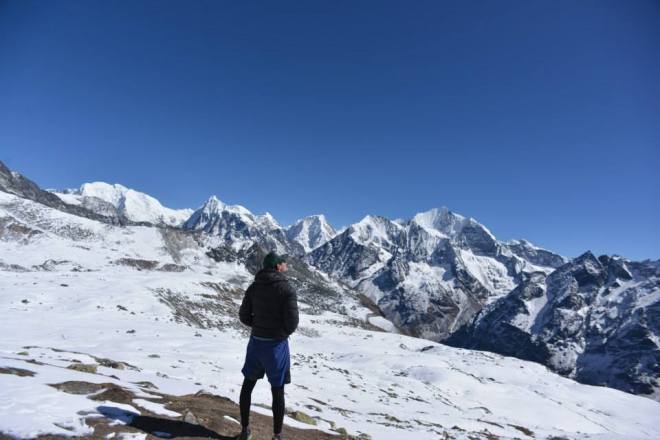
Hereafter I walked up in the Langtang Valley towards he village of Kanjin Gompa, where I settled for a couple of days to explore the valley. I met some amazing other tourists who were also staying here (Inga, Marlene, Eliel, Eike and Chris) with whom I would share these adventures. After a first snow fall, we climbed up to Kanjin Ri (4774m) for some amazing views of Langtang Lirung. The following day we went up even higher and a long, hard climb took us up to the summit of Tsergo Ri (4984m). During my last day I went up to explore the far end of the valley, where I was only surrounded by yaks with huge horns.

View from Tsergo Ri

View from Tsergo Ri


The next days I tried making my way to Gosainkunda lake, but was severely hindered by three days of snow storms. When I finally made it to Laurebina (3950m) just below the lake, I met up again with Inga, Marlene and Eike who were waiting out the storm. It seemed like it would be impossible to cross the 4600 metre high pass to get into the Helambu valley. After three days of snow and minus 20 degrees, the weather finally improved. The four of us set out for a day-trip to Gosainku lake (4380m). It was an amazing adventure, we had to break trail through snow that was at times thigh high while hiking on a trail clinching to the face mountain with an endless drop-off on our side. But we did it and with rejuvenated hopes Eike and me returned to our guesthouse with the plan to cross the pass the following day.
High up in the Himalaya

High up in the Himalaya


After another glorious sunrise and saying goodbye to our two girls, we set out for a long day of hiking. If we had known up front how hard it would be, we probably would never have started. We could easily follow the trail we made the other day to Gosainkund, but once we got there we still had to make a new trail up till the Laurabina Yak pass (4620m). Wading through deep deep snow, with no trail to follow and trailmarkers deeply covered, took all our strength and persevearance. Furthermore we kept hearing avalanches break off around us, by far the scariest sound I have ever heard in my life. But in the end we safely make it down to the guesthouse in Phedi (3900m) after 9 hours of hard work. We get an incredibly refreshing coke, Dal Bhaat power food, lots of cups of tea, tibetan tea for breakfast and a bed for less than 10 euros.
Looking back at Laurabina Yak pass.

Looking back at Laurabina Yak pass.


The last couple of days we walk out through the Helambu trail and make our way back to Kathmandu where further adventures await us. It had been an amazing adventure and more await.

More pictures can be found here.

Namaste,
David

So this is where it ends for me…

… I’m on a water-less stretch 25 miles just South of Mount Whitney, the very bottom of the high part of the Sierra Nevada. I filled up my water-supply to full capacity a couple of hours ago at Chicken Spring Lake and had been in a long decent since reaching Cottonwood Pass. I had hiked long past sunset into the darkness last night and somehow lost my maps for this part of the trail. Since the PCT gets the most traffic around here, I stuck with following the main trail. But for the last hour had been doubting this strategy. I went with my gut-feeling, pulled out my smartphone and with the last 2% of my battery remaining checked my position … I had walked four miles of the trail. I dropped down my bag and started to process this last bit of bad news.

Ten days ago I had left the small town of Lee Vining where I holed up to weather out a storm. I was now getting on to one of the most beautiful as well as daunting stretches of the Pacific Crest Trail: the High Sierras. A long stretch over several high passes with little options for resupply along the way. The first four day stretch takes me through the back country of Yosemite National Park along two pack stations, Reds Meadow and Vermilion Valley Resort. I have got a resupply package waiting for me at VVR, so I only have to carry a light backpack. I get lucky at Reds Meadow when my neighbours on the camping invite me over to their fire-pit to feed me food and beers. They even show me the way to a hot-spring nearby where I go and soak for an hour after dinner. At VVR I get my last resupply, I plan on walking the next 186 miles / 300 kilometres with leaving the trail. All the food for this stretch has to fit in my bear canister. This means I have to fit all the food for the next seven days in this bucket and actually can’t take as much food as I would want to. But even now my backpack feels heavier than I have ever felt it before.
Sierra Nevada overview
The following days are amazing. Each day I walk to postcard-like sceneries, with impressive mountains surrounding me and deep-blue lakes that beg me to stop for a swim. I cross four big passes that are over 3000 metres / 10000 feet high: Mather, Pinchot, Glenn and Forester pass. Each time I have to conquer hundreds of switchbacks upwards to get to these points and each time and each time I get rewarded with amazing 360 degree views.

But at the same time, it becomes mentally harder to motivate myself to keep going every single day. It’s already mid October and there aren’t that much other hikers out there any more. The lack tof a sociable aspect is weighing hard on me. At the same time The days are becoming shorter which means I have to hike even faster and often past sunset into the dark. I’ve already been hit by snow twice and every day feels colder out there.

In the end all these aspects come together and over the last days at the end of the High Sierra I’ve decided that I will leave the trail at Southern Kennedy Meadows. I no longer felt that the joy I got out of hiking outweighed the harshness and isolation. So when, on that faithful morning, after taking a wrong turn coming down from Cotton Pass, I all of the sudden end up in Crabtree Meadows, I decide to finally finish my hike. I no longer have the energy in me to go further.

I might return some day. Give it another attempt to complete the whole trail. But for now, I’m satisfied. I’m proud of every step I took. I hiked 927 miles or 1493 kilometres through the amazing outdoors of the American West Coast.
019 (43)
———

It’s been almost three months since that day I decided to get off the Pacific Crest Trail and it seems that I’m finally ready to write about my last days on the trail. I believe it is just as well a testament as to how hard it was to walk away from the trail as it is a testament to difficulty of keeping a blog up-to-date. I’m now spending my last days in Belgium before I set out for another adventure.

In the last weeks I’ve put together some videos about my life on the trail. Nothing fancy, but some might like it. First bit is in Dutch, rest is in English.


And you can find some pictures right here.

Le Tour De Taiwan – Day 29

28 days later… and I’m getting close to the end of my bicycle trip around Taiwan. Fortunately I saved the best for last!

View From Hehuan Mountain Main Peak

Sunny View From Hehuanshan Main Peak

Fugang – Hualien

After an overdose of relaxation on Orchid Island, the ferryboat took me back to the picturesque little harbor of Fugang. The time I jumped on my bike, darkness was falling. But I didn’t mind getting a dusky ride. Around 11 PM and 100 km further north I pitched my tent on a campsite with the well–sounding name “Shihtiping” in the small town of Fengbing.

A perfect spot, if it wasn’t for the grumpy man brusquely waking me up the next morning around 6 AM. The angry gentleman turned out to be the owner, requesting me to pay 8ooTWD. An absurd amount for my ridiculously small one-person tent sadly placed in the grass (for comparison: a hostel dorm usually costs around 500 TWD). After a long and difficult negotiation involving my hands, feet and a site named “google translate” I paid 400 TWD and continued my journey. A campsite named “Shihtiping”? I should’ve known…

Fengbin Harbor Early in the Morning

Fengbin Harbor Early in the Morning

The remaining stretch from Fengbin to Hualien city was short. And as the nightly biking the previous day went well, I was all set for an easy day of relaxed cycling. On arrival in Hualien I realized that it was short, but definitely not as effortless as expected. To make my point:

Elevation profile Fengbin - Hualien City

View Along the Coastal Road to Hualien

View Along the Coastal Road to Hualien

Hualien – Taroko – Hehuanshan

Since I left on the bike, I had been thinking about climbing one of the many mountains in Taiwan. And after all, what would “Le Tour De Taiwan” be without a decent “queen stage”? Back in Taipei, Cecilia had shown me footage of her heroic climb of Mt. Hehuan (aka Hehuanshan aka “Joy Mountain”) during wintertime. Great inspiration! The climb is extra interesting because of its accessibility. The main peak can be climbed from Wuling (at 3,275 m the highest  pass in Taiwan). Moreover, the road to the climb from Hualien crosses the magnificent Taroko National Park.

The profile of the climb (more here – Taiwan Kom Challenge):

Elevation Profile Hualien - Hehuan Mountain

Elevation profile Hualien – Hehuanshan Mountain

I decided to pitch up my tent around Heliu in the Taroko gorge (altitude 400 m) Sunday late afternoon. The next morning I woke up at 5AM to tackle around 60 km of climbing towards the town of Guanyuan (altitude 2.374 m).

Taroko Gorge Valley View

Taroko Gorge Valley View

The climb was physically challenging with the MTB and the extra weight wasn’t helping to get up faster either. Luckily more than enough reasons to forget the physical strain: a beautiful sunrise, my very first encounter with (shy) Taiwanese monkeys and the majestic natural surroundings all along the way. Sometimes though, the road got dangerously close. Luckily warning signs were provided 🙂

Road close

Beware: Road Close

After a short night sleep in the Youth hostel in Guanyuan (there’s only one just in case you were wondering) I got started for the most beautiful part: the actual ascent towards Hehuanshan Mountain. Only 17 km between Guanyuan and the final climb but no doubt the hardest bit on the journey so far. Several parts have an elevation percentage above 12%. However, every bit of the journey was worth it. The view at 3.416 m above sea level on the main peak of Hehuanshan is stunning!

Hehuan Mountain Main Peak

Hehuan Mountain – 3.416 m

Le Tour De Taiwan – Day 18

I’m writing from Lanyu (Orchid Island), a small volcanic island off the southeastern coast of Taiwan. The plan was to spend 4 days on this little piece of paradise. However, because of the rough sea, yesterday’s boat was canceled. The perfect moment to write a short report about the last 9 days of cycling and traveling through the “Ilha Formosa”.

Heading From South to East

Heading From South to East

After having spent a day of exploring around Kenting, I got back on the road towards the east coast of Taiwan. Because of the strong wind, I was moving slow. Not that much of a problem considering the breathtaking scenery around me.

Breathtaking View Cycling Towards the East

Breathtaking View Cycling Towards the East

I decided to give my legs some rest and my upper body some work in the relaxed surfer town Jialeshui where I crashed at Winson’s house. Two days later, after a late afternoon surf session I bumped into another (crazy) Belgian! Koen is a fellow Prince Albert Fund alumni that spent one year working in Taipei. As we were moving in the same direction, we decided to bike together the next morning.

Surfing is So Happy

Surfing is So Happy…

Sunset in Jialeshui

Jialeshui Sunset

We took off early for one of the toughest but most beautiful “stages” of Le Tour de Taiwan until now: Jialeshui to Taimali (to see the route click here).  It was great to have a companion during the 115 km long ride in the sweltering heat on a hilly route (1551 m of incline). For those wondering where I get the stats from: Koen is an electrical engineer interested in technology registering our every move with one of his many useful apps.

Jialeshui - Taimali

Jialeshui – Taimali

Quite remarkable are the many “police stations” along the road. The criminality must be close to zero in most of the east as the stations function as “bicycle service areas”, invariably staffed with policemen keen on providing food, water, a place to sleep or information about Taiwan.

Police Station or Service Station for Cyclists?

Police Station or Service Station for Cyclists?

Sleeping Spot in Taimali

Sleeping Spot in Taimali

After a short and rainy night, we got up at 4.30 am and drove 30 km towards the pretty harbor town of Fugang. We arrived around 7 only to find out that the ferry wasn’t leaving until 9.30. Luckily we found shelter in one of the nearly five thousand (!)  7-ELEVEN stores in Taiwan.

Fugang Port

Fugang Port

The last few days on Orchid Island were spent snorkeling, diving and hiking. In short: enjoying life. However, the desire to head towards the mountains is growing. Hopefully the sea will be quiet enough to catch the scheduled ferry on Tuesday so I can continue my journey!

Port of Lanyu

Port of Lanyu

Diving

Two Crazy Belgians and One Crazy Fish

Lanyu View

Lanyu View

Sunset over Lanyu

Lanyu sunset

This American Life …

Since starting the second leg of my PCT adventure, I have had one faithful companion: a podcast named This American Life. Hosted by the amicable Ira Glass it’s a story telling program on American Public Radio that each week touches upon a different, interesting subject. Before leaving San Francisco I downloaded about forty episodes and I’ve listened to almost all of them by now. They’ve been an amazing distraction when the hiking becomes harder or a good story at night during dinner. This weeks blogpost will be structured in a similar way. Stay with us.

Act 1: Hospitality

I’ve been incredibly fortunate with all the people I’ve met on and off the trail. I’d like to share a story about an amazing couple I met in South Lake Tahoe. After coming off the trail at Echo Lakes, the people running the shop out there were closing up because of the upcoming winter. However they gave me a free can of soda and showed me how to get to the highway. Once I got there, I did a small attempt at making myself look presentable and then put up my thumb. After about fifty cars had passed, a car came back from the opposite direction and made a U-turn. The driver jumped out and threw some of his gear in the backseat to make room for me. Whilst driving into South Lake Tahoe, Nicholas – the driver – and me got more acquainted. He’s 26, married and working as a waiter whilst getting ready to study for his medical exams.

Once we drove into town, he invited me to stay at his house instead of going into a more impersonal hotel, off course I agreed. We picked up some sandwiches for lunch and went to his home, where I got to meet his lovely wife Kadi. Afterwards we went out to play discgolf and swim in South Lake Tahoe. In the evening we got pizza and watched Death Proof. It felt like spending a day with friends I just had never met before. The only difference was that at night, Nicholas – who is a devout christian – spent a couple of moments praying for my health and success in this undertaking. A small but very moving gesture.

Hiking near Sonora Pass

Hiking near Sonora Pass

Act 2: A lonely hiker

I’ve been out on the trail for two weeks now and I can feel that the solitude of being out there by myself sometimes gets to me. There are some other long distance hikers out there around me, but I haven’t met up with them yet. Since the days are becoming shorter and the weather is getting colder, there are less day-hikers out there as well. So I’ve spent several days out there not meeting a single soul whilst I’m hiking the trail. Sometimes it becomes a bit hard on me, missing human contact or just a listening ear for all my plans for the future that run through my head. I guess that I’m not the hermit I once thought I was and that’s not a bad thing.

The lonely hiker

The lonely hiker

Act 3: A change in weather

Leaving Nothern Kennedy Meadows, the last weather forecast gave a 20% chance of a little snowfall for the next day. Hoping the prediction was only a false alert, I set out for the next stretch of hiking. Unfortunately it turned out to be true. The following afternoon started of with a drizzle and then some hail. After hiking for three hours in near freezing temperatures I decided to call it a day and put up my tent. It turned out to be a fortunate decision, the weather turned for the worse and when I woke up in the middle of the night I was surrounded by a nice 10 cm / 4 inch layer of snow. Breaking up my camp to go out again proved to be a long task with freezing cold fingers. However beautiful the snow might be, it also slowed me down for my hiking the next couple of days.

A snow covered scenery in the Sierra Nevadas

A snow covered scenery in the Sierra Nevadas

Fortunately I could bail out to Lee Vining, a small town on the East side of the Sierras, before I ran out of food. I got here yesterday (Tuesday) and will eventually spent two unplanned nights in this sleepy town. I hope that by tomorrow the early fall storms have passed through and a spell of dry, good weather will come in (at least that’s what the locals are predicting).

So tomorrow I’m heading out again for what should be one of the most beautiful stretches, up in the the high Sierras, straight through Yosemite National Park. It’s also the stretch that will take me over several passes above 3000 metres and some nights the temperature might drop till -10 Celsius.

I’m hoping for a lot of sunshine and other hikers to run in to.

Happy trails,
David

Le Tour De Taiwan – Day 9

After a good night sleep I got on the road together with Hom Yian, Cecilia’s dad. Hom Yian is (besides friendly and generous) a worried Asian father and wanted to make sure I’d safely make my way out of Taipei. So he decided to join me for the first day.  At times it must have been hilarious to witness us  communicating, in a language we both don’t speak. A remarkable duo to say the least 🙂

Ready to go!

The first three days on the bike were quite challenging. After having spent a wonderful time enjoying city-life in Taipei, it was hard to get adapted to the cycling rhythm. A burning sun with temperatures well above 30 and the realization that I should have packed lighter were not making it any easier. Next to that, along the west coast of the island there’s a lot of heavy industry. Understandably this does not make it the most beautiful area to be cycling through. Finding sleeping space or a spot to pitch my tent was hard as well. So I had to turn to the Almighty Buddha again. The first night I slept in a small Buddhist “chapel”. The second night, the Buddha’s smile turned even brighter and I enjoyed a (free) stay in a full-blown temple (with bedding, hot showers and stunning sunset).

Sleeping Spot First Night

Sleeping Spot Second Night: Fangyuan Temple

Sleeping Spot Second Night: Fangyuan Temple

Sunset Near Fangyuan Temple

Meanwhile, some friends had notified me about typhoon Usagi moving closer to Taiwan slowly but steadily. I decided to bike to Tainan where I met up with the local mermaid-girl Trista (thanks for the referral Joanne!). Once again I found myself amazed by the genuine hospitality of Taiwanese people as I was celebrating the Moon festival together with Trista and her lovely family. Thanks for the wonderful time we spent together and the tasty Taiwanese food you made me try!

With another 5 extra kilos I made my way further south (to the city of Kenting). The scenery has changed and I am now experiencing the true (natural) beauty of Taiwan. Some shots along the way and during a trip I made today:

Entering Pingtung County

Namwan Beach Tractor

Nanwan Beach Tractor

Houbihou Port. No Fishing

Baisha Beach

Baisha Beach

Sunset Near Guanshan

Guanshan Sunset

Tomorrow I’m planning to continue my journey towards the east side of Taiwan. Looking forward after what I’ve seen last few days!

P.s. Sometimes I miss Belgium.

Belgian Beer. Available in Taiwan as Well!

Sometimes I Miss Belgium 🙂

Le Tour De Taiwan – Day 0

I’m writing from the city of Taipei where I’m staying at Cecilia’s place. Cecilia is a young Taiwanese writer/artist David met a couple of years ago while trekking through Kyrgyzstan. It truly is a small world indeed. Thank you Cecilia for the generosity/inspiration and David for the referral.

Tomorrow morning I’ll be heading out for my own version of “Le Tour de Taiwan”. After some final preparations today (buying a tent and picking up Cecilia’s bike), I’m all set for this new little adventure. My estimation is to be on the road for the next 3 weeks, covering around 1.500 km (distance/time will greatly depend on how many times I get lost and whether or not I’ll attempt to climb Mt. Hehuan). I’ll try to regularly post updates about my (cycling) experiences in the time to come. Now, however, I urgently need to “hit the sack”.

Testing the Bike in New Taipei City

“Testing” the Bike in New Taipei City

On the trail again …

although it is unclear for how much longer. Still plenty of doubts ahead, but we’ll get there soon enough. First let me get you up-to-date how the last couple of weeks have been.

After my two failed attempts to restart my hike in the first weeks of August, I have hitchhiked down the West Coast to continue my adventure. After going through Bend and Oregon; I went into Humboldt County, a beautiful coastal stretch in the very North of California. I had some amazing times: sleeping on the beach at College Cove and a transformed school bus in Orick, walking through giants in Redwoods National Park, people watching in the university town of Arcata, …

Around the 20th of August I made it back to San Francisco where I could count on the amazing hospitality of my friend Tom and his housemates. After a couple of days of preparation met up some old friends from Mexico City and headed out to Burning Man. For the third time in four years I was going home.

It turned out to be a very intense experience, more emotional than my previous two visits. I was strongly doubting about what I would be doing after the festival and what my future would look like. There were some old friends I’ve run into and memories to be relived.

After a short time back in San Francisco I decided to head out for the Pacific Crest Trail. Doubts where raging through my head. Most of all I was afraid to go out there and have my body fail on me once again. To start hiking and realize that the pain would just be too much. At the very last moment I headed out with Ila (Tom’s girlfriend) for a practice hike in San Francisco. Hiking with a full backpack through SFO seemed like a bit odd, but the feeling in my legs was good so I decided to go out for it.

Some amazing trees along the way


A busride took me out to Truckee and from there I made my way to the trail. I had a 66 mile (106 km) stretch ahead of me, all the way to Lake Tahoe.

The first two days were going very smooth. It felt great to be back on the track, as if I had found a purpose again. Walking on the trail felt like coming home to me. You can hear me talking about this in the following fragment.

However in the following two days, the pain in my shins returned and with it returned the doubts that were going through my head.

I made it all the way to Lake Tahoe and although my shins feel painful, I can manage. The feeling is still bearable. So for the moment I will continue on this trip that takes me further in to the Sierra Nevada. Step by step, day by day. Living in the moment.

Aloha Lakes